East Weatogue Historic District
- District Overview
- Inventory List
- Town:
- Simsbury »
- Year of Establishment:
- 1987
- Overlapping Historic Designation(s):
- LHD, NRHD, SR
- District Authority:
- Historic District Commission
- Link to Commission or Municipal Website:
- Map:
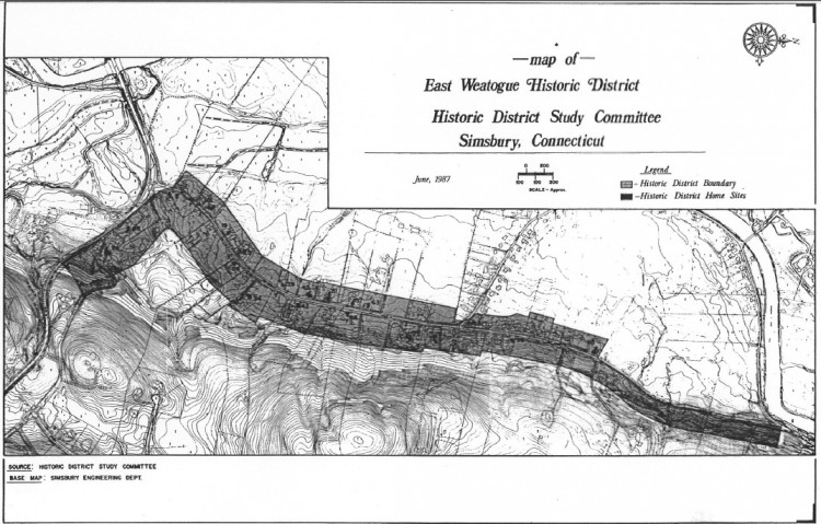
-
Map of the historic district retrieved from the Historic District Study Committee Report, 1987, SHPO library, Hartford.
View photo - District Character:
- Rural Neighborhood
- Features:
Buildings, Farms, Open Space
- Architectural Style:
Colonial, Federal, Greek Revival, Italianate, Queen Anne, Colonial Revival
- Era:
- 18th Century, 19th Century, 20th Century
- General description:
The East Weatogue Historic District runs along East Weatogue Street and Hartford Road, east of the Farmington River, in Simsbury. One of the three nucleated settlements in Simsbury, the East Weatogue Historic District retains an agrarian appearance with much of the acreage still in use for farm purposes. The houses, barns, and other outbuildings date from the 18th century and reflect architectural styles and building practices from the 18th century through the mid-to-late 19th century on into the early-20th century. In Simsbury, two village sites are known. The main one was Weatogue, meaning home place. Indian artifacts found on three farms within the district enrich the ancient history of East Weatogue. Several sites have been the subject of study in the Farmington River Archaeological Project of the Department of Anthropology of Central Connecticut State University. [NR & 3]
- Significance of the district:
The East Weatogue Historic District is significant historically because it is an exceptionally well-preserved rural village which has survived in spite of its proximity to the major city of Hartford, Connecticut. The East Weatogue Historic District is significant architecturally because it displays good examples of architectural styles from the Colonial to the Colonial Revival in their original setting and relationship to one another, little altered over time. The land and the people worked together to form a community of exceptional longevity. Today the houses and the fields continue to give the sense of place that can only be developed gradually over the centuries. The architecture of the houses and the agricultural function of the land constitute an entity that is a significant cultural resource. The continued use of the land over the centuries for agricultural purposes complements the historic architecture that has survived in well-preserved condition in the shadow of a large city. The houses in the East Weatogue Historic District remain a concentration of fine 18th- and early-19th century structures. They are well-preserved examples of historic styles and building types. Because over time the houses have responded to need for changes, they are a living record of a community and the changes that have occurred in its fabric. But the relationship of the buildings to one another, set close to the scenic road and interspersed with large tracts of open land, has not changed. [NR]
- District Boundary (according to the LHD Study Report, copied in 2010):
The district includes properties on both side of East Weatogue Street and few properties along Hartford Road, Pinnacle Mountain Road and Talcott Mountain Road with varying setbacks as described in the ordinance.
- Sources:
[1] District information retrieved from the town website http://www.townofsimsbury.com/Public_Documents/index. [2] East Weatogue Historic District, Report of the Historic District Study Committee, 1987, SHPO Library, Hartford. [3] Handbook of the Historic District Commission accessed from the town website, http://www.townofsimsbury.com/Public_Documents/SimsburyCT_PlanningZone/Handbook%20of%20the%20Historic%20District%20Commission.pdf. [4] Assessors information and Parcel IDs retrieved from the website http://www.prophecyone.us/index_prophecy.php?town=Simsbury. [5] GIS information retrieved from the website http://www.crcog.org/GPV/Viewer.aspx.[NR] Ransom David F., East Weatogue Historic District, National Register Nomination Number- 90001107 NRIS, National Park Service, 1990 - http://pdfhost.focus.nps.gov/docs/NRHP/Text/90001107.pdf; http://pdfhost.focus.nps.gov/docs/NRHP/Photos/90001107.pdf.
- Notes:
The local historic district is contained within the much larger National Register historic district.
- Disclaimer:
Content for this website and district boundaries were compiled from several sources and are subject to change. Boundaries for LHDs may be different from those of State or National Register Districts. To verify the boundaries and particulars of a specific district, consult the LHD study report on file with the respective municipal authority or the State Historic Preservation Office.
- Date of Compilation:
- 12/31/11
- Compiler:
- Manjusha Patnaik, CT Trust for Historic Preservation
