Machamux Boulder- West Parish Common
- Property Overview
- Inventory List
- Property Map
- Historic/Common Name:
- The Common
- Address:
- 250 Greens Farm Road
- Town:
- Westport »
- Year:
- _
- Historic Designation:
- LHP, SR
- Property Authority:
- Historic District Commission
- Features:
- Granite Boulder, Open Space, Landscape features like picnic tables.
- Historic Use:
- Residence, Meadow
- Present Use:
- Park
- Architectural Style:
- _
- Era:
- 17th Century
- Map:
- {# if eligible_for_tax_credits}
- Eligible for Historic Home tax credits:
- Yes {/if #}
- General description:
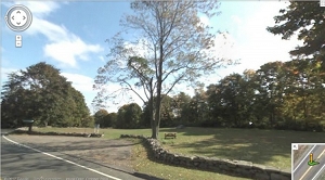
The Machamux Boulder is sited on the old 'Common' land in what was the original West Parish of Fairfield, later to be named Greens Farms, after John Green, one of the original Bankside Farmers. It is a commemorative granite boulder with a bronze plaque dedicated by the Compo Hill Chapter ad Friends of the DAR. The parkland setting overlooking the Connecticut Turnpike once had an unobstructed view of Long Island Sound. The meadow area provided land for the grazing of sheep, cattle and horses, surrounded by some of the original public buildings such as the first meeting house and school. [2]
- Significance of the property:
The original three 'Bankside Farmers'- Thomas Newton, Henry Gray and John Green, left the lands of Fairfield and crossed over to settle east of Sasco Creek along the 'sea banks' in the area known as Maximus. The land purchased by them from the Maximus, aka Machamux, Indians included the territory extending one mile west from a white oak tree near Frost Point to a distance one English mile west to Compaw (aka Compo). The 17th and 18th century Fairfield land records frequently made reference to the 'common land' in the west farms which later became the West Parish. Many sales and divisions took place, carving away at the land held in common by the early inhabitants. These transactions left very little public space in what came to be called Greens Farms, named after John Green. The area commemorated by the Daughters of the American Revolution by a boulder and plaque now on the green at 'Maximum' (spelling from the original deed) is all that remains of the 'Common' area reserved for the public good and welfare. The significance of the area is cast in bronze: MACHAMUX- The name according to legend means the beautiful land and was named by Chickens, a young sachem who settled here. [2]
- Relationship with the Surroundings:
The Machamux boulder is sited on a wide expanse of flat open land over-looking the Connecticut turnpike and Long Island Sound.
- Ownership:
- Public
- Owner:
- Town of Westport
- Sources:
Assessors information retrieved from the website www.visionappraisal.com.
[1] Historic Property information retrieved from the town of website http://www.westportct.gov/.
[2] McWeeney Lucinda, Machamux Boulder, Historic Resources Inventory, 1989, SHPO library, Hartford.
[3] Historic District handbook accessed in the town website [http://www.westportct.gov/modules/showdocument.aspx?documentid=280].
GIS information retrieved from http://www.westportct.gov/index.aspx?page=538.- Date of Compilation:
- 12/31/11
- Compiler:
- Manjusha Patnaik, CT Trust for Historic Preservation
Map of the historic property retrieved the study report, SHPO library, Hartford.
View photo