Mansfield Center Historic District
- District Overview
- Inventory List
- Town:
- Mansfield »
- Year of Establishment:
- n/a
- Overlapping Historic Designation(s):
- LHD, NRHD, SR
- District Authority:
- Historic District Commission
- Link to Commission or Municipal Website:
- Map:
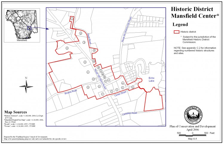
-
Map of the historic district retrieved from the town website, http://www.mansfieldct.gov/filestorage/1904/1932/2043/map_04a.jpg.
View photo - District Character:
- Rural Village
- Features:
Buildings, Open Spaces
- Architectural Style:
Colonial, Federal, Greek Revival
- Era:
- 18th Century, 19th Century
- General description:
The first settlement in Mansfield, in about 1692, was at Mansfield Center, in a quiet valley south of the university. A highway eight rods wide was laid out and the land on either side was divided into twenty-one house lots. With each house lot came the right to 1000 acres in outlying parts of town. Gradually the woods were cut for building and on the clear land crops were grown and cattle pastured. As the outlying land was used, highways were built, resulting in a road pattern resembling spokes from a hub.The Mansfield Center Historic District today remains essentially the same village it was in the 18th and 19th centuries. There is a general store, a library, the town hall the Congregational Church, and an elementary school in the vicinity. The well-kept houses of Colonial, Federal, and Greek Revival styles are obviously cared for by conscientious owners. Of large proportions with some detail and ornamentation, the homes give evidence of the wealth derived from, local agriculture and commercial activity in neighboring towns. As industry became the major force in the development of towns in the mid-19th century, mills and manufacturing sprang up on the rivers surrounding Mansfield Center, in Willimantic and Stafford Springs. The architectural characteristics of the area provide a sense of identity for the contemporary district with village life of the 18th and 19th centuries. There is a great sense of unity among the residents, many are professors at the university; all are people who take great pride in their homes and their community. There is much interest in the preservation of the Center as an unspoiled rural village. [NR]
- Significance of the district:
Architecture-The way in which Mansfield has developed during the past two and a half centuries accounts for the historical and aesthetic quality still evident in the village of Mansfield Center. The Mansfield Center Historic District extends over the area of original settlement and includes twenty-six homes as well as the library, general store, town hall, and Congregational Church.
One of the most impressive parts of the Mansfield Center Historic District is north of the church. Here is located the oldest house in town (c.1710), a very large Greek Revival residence, five 18th century houses, several early 19th century and Greek Revival structures, and the library. [NR]
- District Boundary (according to the LHD Study Report, copied in 2010):
The district includes properties along the following roads- Storrs Road (Route 195), Browns Road, Dodd Road, Center Road and few properties towards west of Echo Lake; as described in the district ordinance.
- Sources:
[1] District information retrieved from the town website http://www.mansfieldct.gov/.[2] Mansfield Hollow Historic District, Report of the Historic District Study Committee, 1976, SHPO Library, Hartford. [3] GIS information and Parcel IDs retrieved from http://www.mainstreetmaps.com/CT/Mansfield/. [2][NR] Babbitt Susan, Mansfield Center Historic District, National Register Nomination Number- 72001337 NRIS, National Park Service, 1972 - http://pdfhost.focus.nps.gov/docs/NRHP/Text/72001337.pdf; http://pdfhost.focus.nps.gov/docs/NRHP/Photos/72001337.pdf.
- Notes:
The local historic district and the National Register historic district are similar in extent but not coterminous.
- Disclaimer:
Content for this website and district boundaries were compiled from several sources and are subject to change. Boundaries for LHDs may be different from those of State or National Register Districts. To verify the boundaries and particulars of a specific district, consult the LHD study report on file with the respective municipal authority or the State Historic Preservation Office.
- Date of Compilation:
- 12/31/11
- Compiler:
- Manjusha Patnaik, CT Trust for Historic Preservation
