Naubuc Avenue Historic District
- District Overview
- Inventory List
- Town:
- East Hartford »
- Year of Establishment:
- 1985
- Notes on Establishment:
- An extension to the district proposed in 1998 was defeated.
- Overlapping Historic Designation(s):
- LHD, NRHD, SR
- District Authority:
- Historic District Commission
- Link to Commission or Municipal Website:
- Map:
-
Map of the local historic district overlaid above the National Register historic district; Source- NRIS 98001439.
View photo - District Character:
- Suburban Neighborhood/ Rural Village
- Features:
Buildings
- Architectural Style:
Colonial, Greek Revival, Italian Villa, Octagon Mode, Queen Anne, Colonial Revival, Tudor Revival, Bungalow
- Era:
- 18th Century, 19th Century, 20th Century
- General description:
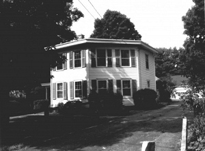
The Naubuc Avenue-Broad Street Historic District is located in the southwest corner of the Town of East Hartford. Generally situated between South Main and Porter streets on the east and the Connecticut River to the west, the district lies just over the border with the Town of Glastonbury. To the southwest is Keeney Cove, which joins the Connecticut River in Glastonbury. Broad Street enters the district from the east, Naubuc Avenue from the south, and they intersect at the district's north end. East Hartford was settled in the seventeenth century by proprietor families of Hartford. Although present-day Broad Street was on the route of the old country road laid out in the early 1700s to connect the river towns on the east side of the Connecticut River, settlement in the district was delayed until after the Revolution. At that time Naubuc Avenue was laid out to Pratt's ferry on the Connecticut River and provided access to nearby Keeney Cove. A small shipbuilding and shipping port developed at this natural river harbor, which was shared with people from Glastonbury. Among the first settlers in the district were river captains John Kentfield (93 Broad Street and 119 Naubuc Avenue) and Jehiel Risley (237 Naubuc Avenue). A generally uniform setback is maintained in the Naubuc Avenue-Broad Street Historic District, regardless of period. The suburban styles of the early twentieth century, Colonial Revival, Tudor Revival and Bungalow, proliferated in the Naubuc Avenue-Broad Street Historic District. Most of these houses were built in the 1920s on small lots, especially on Broad Street, and many have original garages.
- Significance of the district:
Architecture and Social History:The Naubuc Avenue-Broad Street Historic District encompasses a generally well-preserved village that embodies the agrarian and maritime history of much of East Hartford. It derives particular importance from its nineteenth-century association with tobacco cultivation and the regional silver industry, and its later development as an early suburban residential community. The Naubuc Avenue-Broad Street Historic District is architecturally significant for its large collection of well-preserved vernacular domestic architecture, in which the distinctive imprint of local country builders is found on many types and styles from the early National period through the late nineteenth century. It also contains a number of generally well-preserved early twentieth-century houses.
- District Boundary (according to the LHD Study Report, copied in 2010):
The district includes properties on both sides of Naubuc Avenue towards the north of East Hartford- Glastonbury Town line as described in the district ordinance.
- Sources:
[1] District information retrieved from the town website http://easthartfordct.gov/Public_Documents/index.[2] Naubuc Avenue Historic District, Report of the Historic District Study Committee, 1985, SHPO Library, Hartford. [3] Assessors information and Parcel IDs retrieved from the Historic District Study Committee Report [2]. [NR] Cunningham Jan, Naubuc Avenue- Broad Street Historic District, National Register Nomination Number- 98001439 NRIS, National Park Service, 1998 - http://pdfhost.focus.nps.gov/docs/NRHP/Text/98001439.pdf; http://pdfhost.focus.nps.gov/docs/NRHP/Photos/98001439.pdf.
- Notes:
The National Register historic district includes most of the original local historic district established in 1985 and its proposed expansion in 1998 which was not approved.
- Disclaimer:
Content for this website and district boundaries were compiled from several sources and are subject to change. Boundaries for LHDs may be different from those of State or National Register Districts. To verify the boundaries and particulars of a specific district, consult the LHD study report on file with the respective municipal authority or the State Historic Preservation Office.
- Date of Compilation:
- 12/15/11
- Compiler:
- Manjusha Patnaik, CT Trust for Historic Preservation