Sherman Historic District
- District Overview
- Inventory List
- Town:
- Sherman »
- Year of Establishment:
- 1981
- Overlapping Historic Designation(s):
- LHD, NRHD, SR
- District Authority:
- Historic District Commission
- Link to Commission or Municipal Website:
- Map:
-
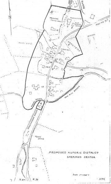
Map of the historic district retrieved from the Preliminary Report of the Historic District Study Committee, 1981, SHPO Library, Hartford
View photo - District Character:
- Village Center
- Features:
Buildings, Cemetery, Brook, Open spaces, Others- Memorial
- Architectural Style:
Colonial, Early Republic/ Federal, Mid 19th Century/ Greek Revival
- Era:
- 18th Century, 19th Century, 20th Century
- General description:
The Sherman Historic District encompasses the center of the Town of Sherman, a community in northern Fairfield County on Connecticut's western border. The majority of the buildings are houses and their associated outbuildings. Schools, a town hall, a library, a store, and a former church complete the Sherman Historic District. Because of the linear settlement pattern, most of the resources are located along the route of a former turnpike, Route 37, the main street of the town. Several streams run through the Sherman Historic District, including Sawmill Brook, which feeds Lake Candlewood, a man-made reservoir to the southeast of the district. Water-powered industry was located along this brook in the nineteenth century. [NR]
- Significance of the district:
Architecture, Exploration, Social History:The Sherman Historic District is significant as a representative village center that demonstrates the patterns of settlement and socio-economic development common to daughter towns in Fairfield County. An exceptionally cohesive and well-preserved district, it contains domestic and institutional architecture in the Colonial, Federal, Greek Revival, vernacular Victorian, and Colonial Revival styles which illustrate the growth of the community between about 1740 and 1937. Many factors contribute to the cohesiveness and integrity of the Sherman Historic District. Few historic buildings have been lost over time and there is little modern intrusion to detract from the historic setting. Physical changes have had minimal impact. The focal point of the district remains on the knoll. Although the original buildings there were replaced by the present nineteenth-century church and school, the elevated site has retained it original colonial function. A rich variety of vernacular institutional and residential buildings line Sherman's roads, establishing the Sherman Historic District's historic character and tracing its development. The Federal style is the first stylistic influence in the district. [NR]
- District Boundary (according to the LHD Study Report, copied in 2010):
The district includes properties towards the south of the junction of State Routes 37 and 39 as described in the district ordinance. For most part, the district follows the natural and legal property lines. The only arbitrary line, which is on the west side of the highway, was selected to include a slope and out-buildings visible from the road. The northern boundary is the knoll which visually dominates the area. The southern boundary is delineated by a brook and on half-acre parcel on the brook. [2]
- Sources:
[1] District information retrieved from the town website http://www.townofshermanct.org/.[2] Sherman Historic District, Preliminary Report of the Historic District Study Committee, 1981, SHPO Library, Hartford. [3] Assessors information and Parcel IDs retrieved from NRIS 91000956. [NR] Cunningham Jan, Sherman Historic District, National Register Nomination Number- 91000956 NRIS, National Park Service, 1991 - http://pdfhost.focus.nps.gov/docs/NRHP/Text/91000956.pdf; http://pdfhost.focus.nps.gov/docs/NRHP/Photos/91000956.pdf.
- Notes:
Situated at the junction of State Routes 37 and 39, the Sherman National Register Historic District includes the historic district established by state enabling legislation and contains 64 contributing and non-contributing resources. [NR]
- Disclaimer:
Content for this website and district boundaries were compiled from several sources and are subject to change. Boundaries for LHDs may be different from those of State or National Register Districts. To verify the boundaries and particulars of a specific district, consult the LHD study report on file with the respective municipal authority or the State Historic Preservation Office.
- Date of Compilation:
- 12/31/11
- Compiler:
- Manjusha Patnaik, CT Trust for Historic Preservation